Author: Your Neighbor in Vineyard

  • Why traffic has gotten so much worse – for most people

    Why traffic has gotten so much worse – for most people

    Dear Utah County,

    One of the most universal occurrences in life is preparing to cook something and realizing you are down an ingredient or two.

    Perhaps you’re making a salad, but the greens have wilted because you’ve procrastinated, opting for yummier options one day too long.

    Perhaps you’re making pancakes, but the kids have used all the milk.  Ok, almost all the milk, Emmaleigh points out there’s still some left.  You need 2 cups though, not the 2 thimbles-full they so graciously left at the bottom of the jug.  

    So what do you do?  Say it’s a Thursday night and you’re planning on the aforementioned salad, but the greens are wilted.  However, you’re determined to eat healthy and will do what you must to follow through!  What do you do?

    Here’s the three main options:

    You live on a rural farm: Mostly likely, the greens came from your large garden.  Easy peasy! Send Emmaleigh to the garden and voila, fresh greens for the salad.  Problem solved in 10 minutes or less, plus Emmaleigh got to help.  

    You live in town or in a city: Most likely, the greens came from a grocery store, and you’ll need to go back. It’ll likely be a 10 minute or so drive there (hope there’s a grocery store in your town), the same back, and probably 5-10 minutes at the store itself. If you’re unlucky the drive can take double or triple that time, depending on traffic and how close the store is. Problem solved in 25ish minutes, maybe longer.  

    You live in town or in a city and you’re super rich: Don’t be silly, you aren’t shopping for yourself or making your own salads.  You pay a chef and/or an assistant to worry about these things.1  Problem solved in 0 minutes.  

    Let’s see how these options have changed in the past 150 years.  The easy one comes first:

    1875 as a super rich person: Chef and servants have it covered.  Problem solved in 0 minutes.  

    1875 on a rural farm: Emily gets greens from the garden.  Problem solved in 10 minutes or less.  

    1875 in town or in a city: Cars didn’t exist, so they walked to the general store or market down the street.  Maybe they rode a horse or old-timey bicycle, but most people walked.  Depending on how far down the street it’d take anywhere from 5-20 minutes.  Lots of buildings had ground floor commercial/retail and upper floor residences, so it could have been as short as a walk downstairs.  

    Photo of Provo Center Street near University Avenue in 1890.

    Now let’s summarize the estimated times from the past two sections

    Living SituationEst. Time Spent – 2025Est. Time Spent – 1875
    Rural10 minutes or less10 minutes or less
    Regular Town/City25+ minutes5-20 minutes
    Super Rich Town/City0 minutes0 minutes

    The super rich and the rural scenarios show the same time, but the regular people living in towns and cities… their trips are longer?  How could this be?  150 years of technological advancement and somehow it takes longer to get groceries. 

    From then to now we’ve invented cars, learned to fly, sent numerous people to the moon, discovered penicillin, eradicated smallpox, discovered and split the atom, created computers and the internet, the list goes on and on.  Yet typical travel time to groceries has increased.  Our maximum estimated time for a typical townsperson in 1875 is shorter than our minimum estimated time for a typical townsperson now.  How could this be? 

    The answer:  Monopolies.  Government-forced monopolies.  These monopolies will be the topic of the next two blog posts. 

    Thanks for taking the time to read,

    Your Neighbor in Vineyard

    1. Note: Of course the chef/assistant also has to spend time getting the groceries, an amount of time comparable to non-super-rich people. The same is true of grocery delivery services. ↩︎
  • Mill Road – A Tale of Two Purposes

    Mill Road – A Tale of Two Purposes

    03.31.2025

    An open letter to Vineyard City Council,

    I’d like to provide a recommendation on how to make Mill Road better for all users, as someone who has lived here in Vineyard for several years and paid attention to Mill Road’s use during that time.  

    I’ve observed that Mill Road really functions as two different roads.  I think the city would do well to play to the advantages of each area and make them excellent at their distinct functions, as opposed to trying to split the difference between two goals and falling short at both.  

    The Blue Section: I’ve observed that the area in blue above is used almost exclusively as an access road, not a thru road.  The wide majority of people are utilizing this blue segment to get to or from a business along Mill Road, to their homes along Mill Road, or to the UVU dome, but they rarely drive through the entire section from Center to 800 N or from 800 N to Center.  This is likely because Geneva is faster and more convenient in just about every way.  

    As a result, I’d recommend you leave Geneva as the thru road and let the blue section be excellent for access.  Have lots of traffic calming, lower speeds (perhaps slow enough that bikers could use the same lanes as cars), a center median potentially with some nice trees, lots of places for people to cross and access things, etc.  No one should have to put their life in danger when crossing the road mid-block or turning left into the Megaplex development, but right now the design speed is high enough that crossing the road, biking on the roadside, or turning left could easily be deadly.  It’s no wonder so few people cross on foot and bike in this section! 

    I want you to really focus on making the blue section pleasant and to focus on building the access and desirability of the nearby destinations, as opposed to focusing on getting people through north to south as quick as possible.  That is an important function, but let parallel Geneva serve that function.  

    The Green Section: 

    I’ve observed the green section above is used for essentially the opposite function as the blue section.  With some relatively few exceptions (mostly people going to the gas station) the vast majority of people use the green section as a thru road, not an access road.  They’re trying to get to Geneva from Center street or the blue section, or vice versa, most people’s destination is not along the green section.  As a result, in all my years of living along Mill Road I’ve never experienced traffic jam in the blue section, they all happen in the green section. 

    My recommendation for this green section is to focus on throughput, with access only as absolutely necessary.  The tricky part here is that, unlike Geneva and 800 N, the section is so short that top speed of vehicles won’t really matter.  You could set the speed limit at 100mph and we’d still have traffic jams there because it’s such a short section.  The issue is how efficient the intersections are at getting as many people through as possible in a given timeframe.  As a result, I’d like you to focus on the intersection efficiency of the green section.  

    I’m not as familiar with intersection design as with traffic calming, so I’ll just throw out some ideas to look into.  The core thing is that I want you to focus on getting the max number of people through an intersection as fast as possible.  

    Some ideas, just brainstorming here:

    • Using a roundabout at center street-mill intersection (continuous flow is often more effecient than stop-and-go traffic lights)
    • Physically separate paths for cars and public transit from those for biking/walking
    • Make more competitive public transit (a bus with 15 people on it can move through the intersection faster than 15 cars with 1 person each)
    • Physically eliminate the remaining left turn onto Mill Road in this section (extend the concrete barrier) to have fewer turns breaking up the traffic flow

    Geneva and 800 N: These have the same purpose as the green section at the end of the day, getting thru traffic through as quick as possible.  In short, I’d recommend you keep them fast moving, low access roads, and have the blue segment of Mill Road serve the access function instead.  

    You may have noticed you drive north-south along Geneva much faster than along State Street despite a similar speed limit in most sections. This is because state street tries to be both a thru street and access street.  It has fairly high speeds (thru road) but also tons of lights and driveways to turn into (access)  This makes State Street stressful and unpleasant to be on from the noise, cars turning on and off constantly, etc but also means that you can’t get anywhere quickly because there’s so much traffic built up at all the lights and so many people turning and forcing you to slow down suddenly. 

    As a result, I recommend you make the number of Vineyard-side driveways and traffic lights  on Geneva between Mill & 800 N be 0 (zero) and instead use Mill Road as the access street.  Same thing for 800 N, don’t allow driveways or lights between Mill Road and Geneva as it’s eventually built out.  In this scenario you’d essentially access all the businesses along Geneva the same way you access the movie theater now from Geneva or 800 N, you go around to Mill Road and then use Mill Road as the access street, leaving Geneva and 800 N to mostly handle thru traffic.  

    Note on car lane counts: I have heard people debating about potentially reducing lanes on Mill Road, so here’s my short input.  

    In the green section the multiple lanes each are very useful and you should keep them, because the greater road capacity means more capacity to go through the intersection at one time, and wait at the intersection without extending the queue line.  Having quality and efficient alternatives to driving would also help in reducing the traffic in this area though, so the car lanes should not undermine a separated use path for biking/walking, and it may be smart to work on better public transit in the area.  

    In the blue section, as noted previously, there aren’t really traffic jams because it’s utilized only as an access street.  The absolute most enormous ”traffic jam” I’ve ever been in on the blue section was 5 cars queued up to turn right onto 800 N, which was cleared quickly when the light turned green 10 seconds after I got to this little queue.  Two lanes each way aren’t really needed in the blue section, but you could have them if you wanted, the real need is for traffic calming and better multi-modal access.  You can have that with two lanes or one lane each way.  Personally I would reduce the lane count because one lane costs less taxpayer money than two and I have heard single lane entries make good roundabout design easier, but if that’s not politically viable then the street can still be a rockstar, postcard-worthy access street with two lanes each way.  The key in the blue section is to focus on access and making it a pleasant destination, whether with 1 or 2 lanes each way.

    Ending note:

    This plan allows Geneva and 800 N to be rockstars at getting people through quickly, and allows the blue section of Mill Road to be a rockstar access street that could be beautified to the point of being postcard worthy, all while allowing safety and convenience for multiple modes of access.  I highly recommend you take this course of action.  Thanks for reading! 

    Your Constituent in Vineyard

  • How to waste $3.7 Billion and justify it to taxpayers

    How to waste $3.7 Billion and justify it to taxpayers

    Dear Utah County,

    Imagine for a moment that you live in Utah County in 2050.  Let’s say you just got a new job in SLC and you’re chatting with a friend about what your new commute would be like.  You’ve identified two potential commute options:

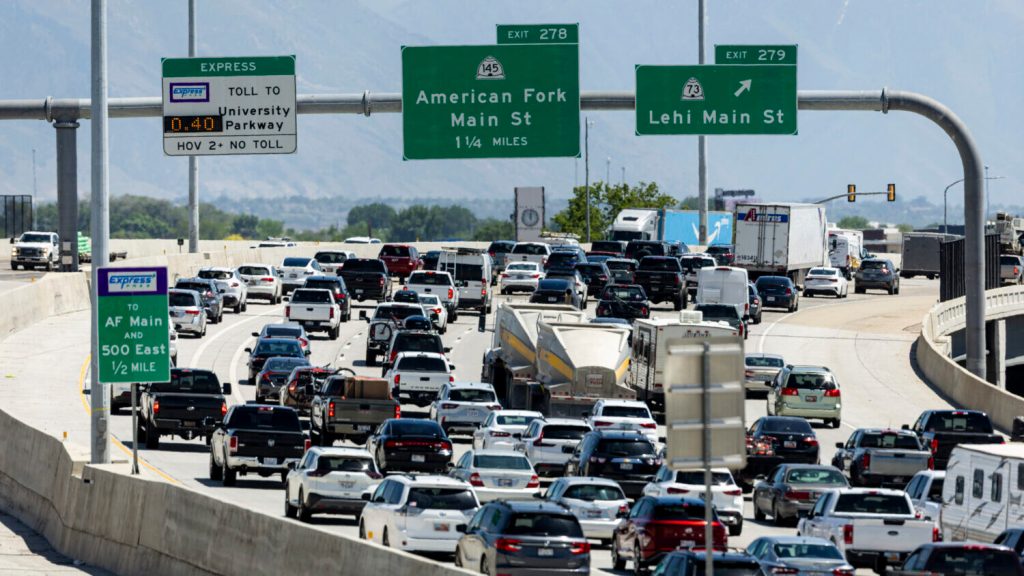
    Option 1: You take a typical car to work.  Maybe it’s electric, maybe it’s gasoline, but you’ll drive it approximately like you do now.  You’ll enjoy breathtaking views of I-15s offramps, freeway medians, rotting roadkill, and of course the other cars in front of you because you’ll have to pay full attention to the road at all times on your 1-hour+ journey to our state’s  capital city.  Yes, it is the future, and your drive to SLC is more than an hour because population has grown.  That’s on the days with no car crashes, of course.  

    Option 2: You take a futuristic mode of travel.  This future travel method only takes 30 minutes to reach your new SLC job, and the advanced technology is so good that it’s self-driving.  You could read a book, you could catch up on work, you could enjoy your breakfast. Of course you’ll miss the stunning views of freeway offramps, instead you’ll have to endure views of open fields, rivers and streams, wildlife that’s alive, and our Utah mountains.  Part of the route will go next to the freeway though, so you’ll at least get a fleeting view of those gorgeous off-ramps.

    Which option would you pick?  Before you read on, sit on that thought for a moment and ask yourself why you picked the option? Was it close?  

    Now seems like a good time to clue you in on the name of your Option 2 technology, it starts with an “F” and ends with a “-rontrunner”.

    Rather depressingly, this isn’t a fictional future I created.  No, it’s a fictional future UDOT recently created, and which UDOT is using to justify a freeway expansion project which will cost an estimated $3.7 Billion.  They’re also planning to bulldoze many homes and businesses1 to make way for the freeway, far more than would be practical to outline here.  All funded by tax dollars, of course.  

    According to a painfully long report which UDOT spent years producing called an EIS, found here, thousands upon thousands of your fellow Utahns would be stuck, unable to pick between these two equal options.  Equal in the eyes of UDOTs traffic model at least (we’ll address why here in a bit).  Traffic models whose details reveal an utterly ridiculous assumption that (in my opinion) effectively invalidates their entire prediction. Don’t worry though, it’s only the core prediction used to justify the entire $3.7 Billion project and all it’s downsides.  Did I mention this proposal has been wildly unpopular and broadly opposed by Utah citizens as well?  Why listen to how your citizens want tax money spent when you can listen to yourself instead!

    At its core, the model assumptions misunderstand what causes traffic. 

    Increased traffic happens when more people choose to drive at a particular time on a particular route

    Intuitively it makes sense that, say, a 50% increase in population would equate to a 50% increase in traffic.  That’s the more people part of that earlier phrase, 50% more people.  That intuition is wrong, however, because it left out the other part of the equation: human choice.  If all else were held equal then yes, traffic would increase by 50%, but this is the real world, all else is not held equal.  More people can equal all sorts of different outcomes, depending on the choices of the population.  

    A change in travel choice can come in many forms.  If your regular route to the grocery store gets more traffic, you might take a different route.  If traffic gets too busy at your usual grocery shopping time, you might switch times. 

    Then there are the bigger choices.  Not many people living in Richfield commute to SLC for work.  Why? Well, a 2 hr commute isn’t worth it to most people, most people would either move closer to SLC or get a job closer to Richfield.  The same is true as freeway traffic worsens, people look for other options. 

    And the last, most vital change in choice is the change in method.  If your kids school drop-off traffic gets too bad at the local elementary school, you might walk them to school instead.  In that case it wouldn’t just be a change in route or timing via car, it would be a change in the transportation method. By the same token, if commute time via car goes from 20 minutes to 60+ minutes while the commute via train stays at a steady 30 minutes, train ridership will increase dramatically.  This is because most people would choose a 20 minute car ride over a 30 minute train ride, and most people would choose a 30 minute train ride over a 60+ minute car ride.  

    This dances around the last key point: Better alternatives will actually reduce car traffic times.  Yes, you read that right.  As stated earlier, increased traffic happens when more people choose to drive a particular route at a particular time.  Well, if a better alternative to driving is available, people will choose the better alternative, and thus their cars will not be on the road to create traffic in the first place.  After all, traffic is made of people in their cars.  If more people are on transit, on their bikes, or walking (instead of in their cars), there’s less traffic for the remaining people who do choose to drive.  This drives us (see what I did there) to the answer of why UDOTs traffic model is so far off: it’s built to predict traffic levels in a world where transit, biking, walking, and all other non-car transportation options are broadly terrible.

    UDOT states that their model (actually the model they are borrowing from the Mountainland Association of Governments and Wasatch Front Regional Council) “…uses existing travel data and then predicts future travel demand based on projections…”.  They continue to state “The model is calibrated to actual, observed traffic conditions…”.  Do you see the problem?  The model is calibrated to historical data.  Historically, would you say you’ve had decent transit, biking, or walking alternatives to driving on your daily commute?  On your trips to the grocery store?  For most people in the recent past, driving has been the best option for almost all daily transportation, and the model was trained on that.  The model has been designed using data from a world where driving is the most common choice to get from Farmington to SLC, so it’s incapable of predicting a world where transit would be the most common choice. 

    Think of it this way:  say UDOT of 1924 had made a model to predict transportation needs in 1950 (as opposed to 2024 and 2050).  Being prudent model creators, they use the most recent data from the 1910s (2010s equivalent) on through their present day, 1924.  Their model, only knowing data from the past, would predict a whole lot of horses and buggies riding around in 1950.  They’d also predict a great deal of train rides, as that was a pretty commonplace form of intra- and inter-city transportation in Utah in the 1910 and 1920s. 

    This would seem an intuitive, smart approach, and the 1924 reports would truthfully claim the model “uses existing travel data and then predicts future travel demand based on projections”, that it would be “calibrated to historical data” but their historical data would be completely incapable of predicting the future choices of future Utahns. 

    In reality, people wouldn’t often choose horses and buggies for transportation in 1950.  Governments would instead choose to make driving an easier and more convenient alternative, ripping up train tracks to make way for larger, paved, roads.  This would simultaneously make driving a better alternative and make train rides a worse alternative, so of course people would change their behavior and drive more.  Such a model would give preposterous predictions about horse and buggy traffic levels, predictions which would be absurd on their face, just like our current model’s prediction of 1hr+ commute times via car when the train only takes 30 minutes.  

    We only think of driving as the default because for so long we’ve chosen to build our infrastructure and our communities with cars as the dominant option.  For decades we have built our roads and communities so that more and more and more people would find it more convenient to drive when they travel, and less convenient to take other transportation methods.  We made a world where driving would be the easiest alternative for most people.  We made a world where more people would drive on any particular route at any particular time.  The result has been worsening traffic and billions upon billions spent in a sisyphean attempt to keep up with it by making driving even more convenient and other transportation even less convenient.  

    If we want to improve traffic, on the freeway or anywhere else, we need to invest those billions into making driving only one of several good options for transportation to any particular destination at any particular time.  I hope you’ll join me in advocating for smarter infrastructure spending and more freedom to choose between multiple quality transportation options.  If we work smart and work together, we can make our towns, our county, and our state into a better place.  

    Sincerely,

    Your Neighbor in Vineyard

    1. You can find their 41-page table here outlining all the directly affected parcels, as well as 67 pages of maps showing the same here.  Those are appendixes 3A and 3B in the EIS report.  ↩︎